

Current Conditions and Future Scenario Maps
Please review the following information and take our survey (también disponible en español) once your review is complete.
Overview
The city's Unified Development Ordinance dictates existing standards and regulations for gas stations throughout the city, which include:
- New stations cannot be within 500 feet of adult or child day care centers, hospitals, elementary or secondary schools, and nursing or group homes
- New stations cannot be placed within 500 feet of an intersection if two of the corners have an existing gas station or other auto-related business
- Gas stations are permitted in industrial zoning districts and conditionally permitted in mixed-use zoning districts
The maps below will outline the current gas station situation throughout Aurora and provide visual examples for what spatial buffers around existing gas stations could mean for the future of development. These scenarios are also available in an online map where they can be explored in more detail (click on the layers button to view the different map layers).
Map: Current Zoning Practices and Impact to Gas Station Development
This first map shows the city limits of Aurora with current zoning practices as outlined within the Unified Development Ordinance and how it affects gas station development. View an interactive version of the map (click on the layers button to view the different map layers).
- Red shows areas where gas stations are not permitted to be developed
- Yellow shows areas where gas stations need a conditional use permit to be developed
- Green shows areas where gas stations are permitted to be developed
- Orange gas pump symbols show the locations of currently existing gas stations
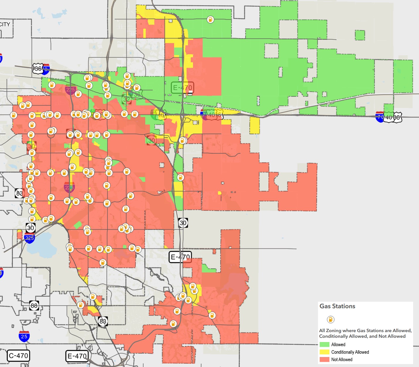
This map shows currently operating gas stations (orange icons in the circles).
Impact of Potential Buffers
Now, these news few maps will show different scenarios and visual examples of what potential buffers around existing gas stations and residential areas would mean for the city. The intention of these maps is to provide a way to visualize these potential futures.
After reviewing these maps, please take our survey to share feedback and comments for consideration in this study.
Scenario 1: Add a 1/4-mile buffer around existing gas stations for new gas station development
This first scenario builds off the same zoning designations and existing gas station locations but also includes a 1/4-mile (1,320-foot) buffer in blue around those gas stations. This would mean new gas stations could not be developed within those 1/4-mile buffers around existing gas stations. View an interactive version of the map (click on the layers button to view the different map layers).
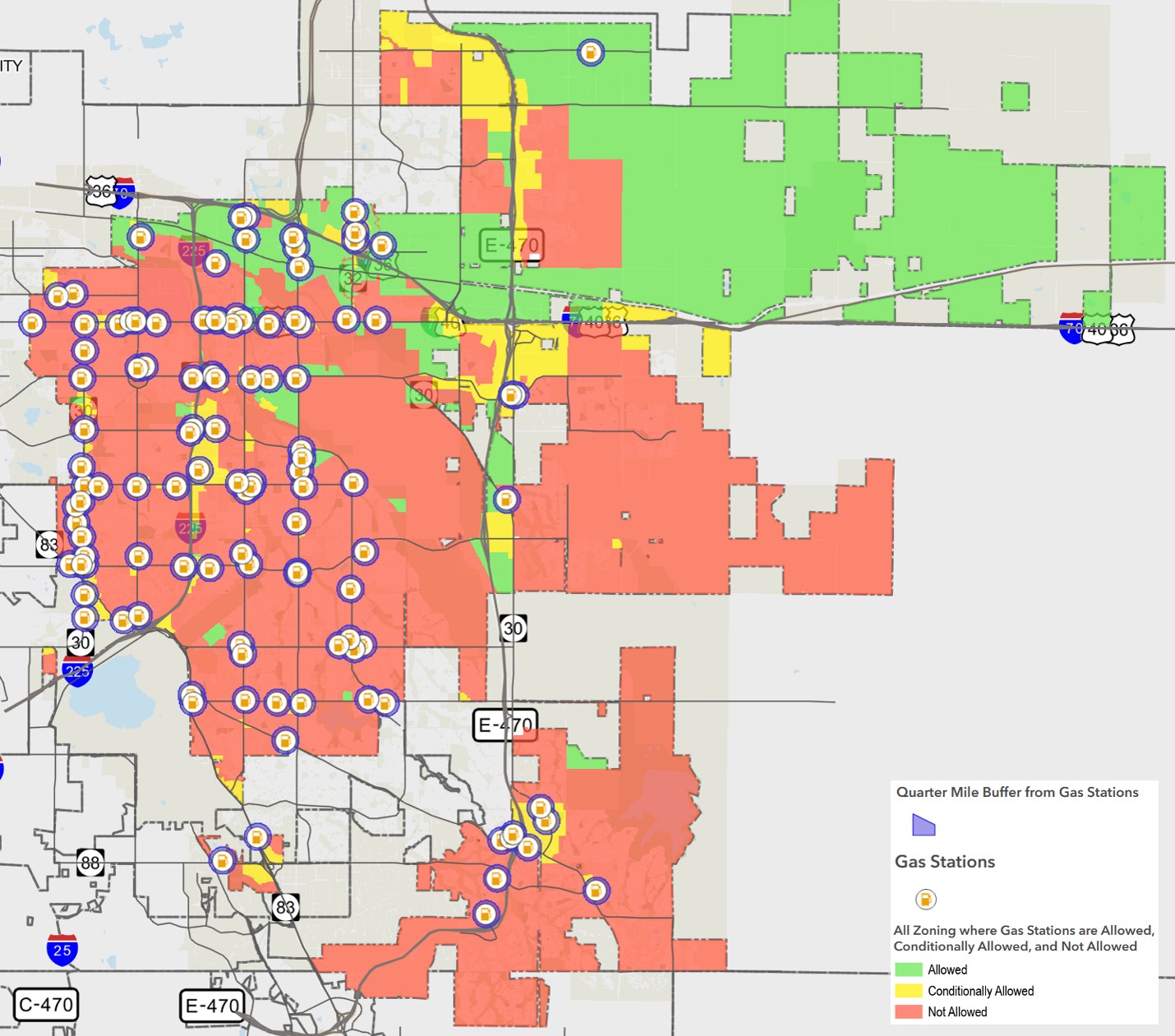 This map visualizes 1/4-mile buffers (blue) around currently operating gas stations (orange)
Scenario 2: Add a 1/2-mile buffer around existing gas stations for new gas station development
The second scenario includes the same elements as before but also includes a 1/2-mile (2,640-foot) buffer in purple around existing gas stations. This would mean that new gas stations could not be developed within those 1/2-mile buffers around existing gas stations. View an interactive version of the map (click on the layers button to view the different map layers).
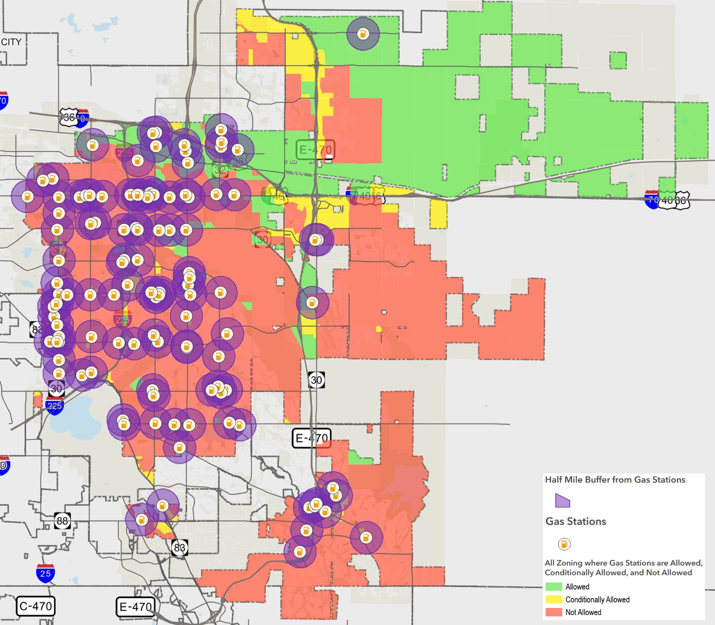
This map visualizes 1/2-mile buffers (purple) around currently operating gas stations (orange)
Scenarios 3 and 4
These next two scenarios illustrate how buffers placed around residentially zoned areas would impact new gas station development. Buffers like these would prevent new gas stations from being developed within the immediate vicinity of neighborhoods and housing in Aurora. This would include areas that are currently zoned residential but have not begun developing.
Scenario 3: Add a 1/5-mile buffer around residentially zoned areas for new gas station development
This scenario builds off the same zoning designations and shows existing gas stations but also has a 1/5-mile (1,056-foot) buffer in black around all residentially zoned areas in the city. This would mean that new gas stations could not be developed within these 1/5-mile buffers. View an interactive version of the map (click on the layers button to view the different map layers).
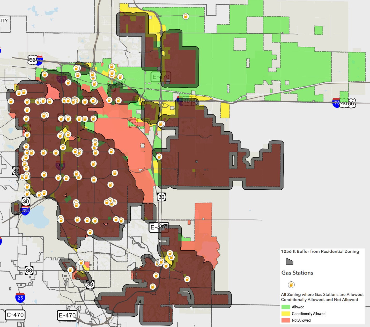 This map visualizes a 1/5-mile buffer (black) around residentially zoned areas along with currently operating gas stations (orange)
Scenario 4: Add a 1/2-mile buffer around residentially zoned areas for new gas station development
This last map illustrates a 1/2-mile buffer in black around residentially zoned areas. This scenario would mean that new gas stations could not be developed within a 1/2 mile of areas that are zoned residential in Aurora. View an interactive version of the map (click on the layers button to view the different map layers).
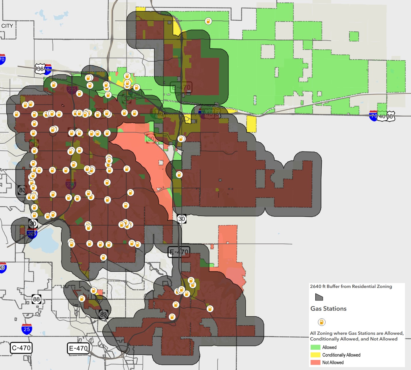
This map visualizes a 1/2-mile buffer (black) around residentially zoned areas along with currently operating gas stations (orange)
The city will collect feedback on these scenarios now through Oct. 31. Feedback will be shared with the Planning and Economic Development Policy Committee this winter.
Please take the survey (también disponible en español) to submit input. We appreciate your feedback!

Thank you for your contribution!
Help us reach out to more people in the community
Share this with family and friends